B A B L I
A WILDERNESS-FARM
AN EFFORT AT LIVING IN
HARMONY WITH NATURE
AN EFFORT AT LIVING IN HARMONY WITH NATURE
~ About BABLI ~
~ Location ~
B A B L I
A WILDERNESS FARM
AN EFFORT AT LIVING IN
HARMONY WITH NATURE
We are located near Santiniketan,
District: Birbhum, State: West Bengal, India.
~ Various Links for Santiniketan ~
Reaching Us
By AIR ~ The closest airport is in Kolkata, the State Capital of West Bengal, India.
By RAIL ~ The nearest railhead is in Bolpur–Santiniketan.
In-between Bolpur and Illambazar, to the west of Santiniketan, our project is adjacent to the Chaupahari Forests (better known as the Illambazar Jungles).
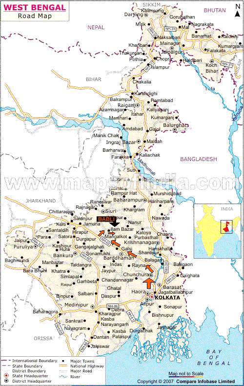
If you take the road going to Illambazar from Bolpur station, B A B L I is 13 km west, which is 7 km before Illambazar.
Geographical Coordinates:-
23.6338897° N 87.6066542° E
By Train :-
-
From Kolkata, take any train going to Bolpur-Shantiniketan.
-
Here's a Link to the Indian Railways website, for your convenience:-
Search with the following coordinates:
Source Station Name :“Howrah”
Destination Station Name :“Bolpur“
Class: “Second Seating”/ “AC-Chair-car“
-
-
At Bolpur station:
-
Avail of the project’s car-pickup – it is a 20-minute ride (See CHARGES) /
-
Rent a car at the station /
-
Take a Tuktuk (rickshaw) to the “by-pass x'ing“, transit to a local bus going towards
“Illambazar“, get off at “Bonovilla“ bus stand, walk 1/4 km to the project.
-
By Car...
By Car :-
-
It is an easy drive, of about three/ three-and-a-half hours (driving time)
-
Travel north-west from Kolkata - along NH2/ AH1 (Delhi Road) - and finally, turn off the National Highway, heading due north ~
There are two possible routes:~
-
Via GUSKARA ~ Which is a shorter route, that travels along scenic paddy-fields, avoiding larger highways ~ Though this route has more habitation along the way, and can be in a bad condition during certain periods of the year.
-
Via PANAGARH ~ A relatively longer route (about 30 Kms more), that includes more of the larger highways ~ Heavy truck traffic can be a bother, at times, where people have been known to get held-up for hours.
You can see Google Map links below, as well as read (and download) driving directions, for both the routes...
Two possible routes:~
MORE SCENIC AREAS
Shorter Route ~
Via:~
BURDWAN ~ GUSKARA ~ BHEDIA
See:~
Via GUSKARA (Shorter Route)
BETTER ROAD SURFACE
Longer Route ~
Via:~
BURDWAN ~ PANAGARH ~ ILLAMBAZAR
See:~
Via PANAGARH (Longer Route)
[Click to open in Google Maps]

~ Go to (Longer Route) ~ Via PANAGARH
[Click to open in Google Maps]
